HIGHWAYS HERITAGE WALKS
By Turnpike and Towpath in Saddleworth
Walk Length: approximately two miles circular.
Grade: easy, on pavements and tow-path, accessible by wheelchair users.
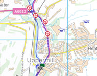
Start:The Saddleworth Museum car-park, High Street, Uppermill.
Grid Reference: SD 99656 05621. Postcode: OL3 6HS
Public transport: Bus 184 from Oldham, Manchester, Huddersfield.
Bus 350 from Ashton, 351 from Rochdale.
Greenfield
Museum carpark is free for up to three hours; roadside parking in Carr Lane or by Civic Hall or swimming pool.
Description
Saddleworth is an old Yorkshire parish made up of a number of picturesque villages including Delph, Diggle, Denshaw, Dobcross, Greenfield and Uppermill. The Pennine ridge is at its narrowest at Standedge and the Roman Military road from York to Chester, the medieval saltways, several packhorse tracks, three turnpikes and the canal and railway have all used this crossing. Our route follows Uppermill High Street and the Wool Road, passing milestones and tollhouses, before turning back along the towpath of the Huddersfield Narrow Canal. Allow time to visit the museum.
Route Instructions
1. Ashton Milestone.
2. Brownhill Tollhouse.
3. Medieval & Turnpike Bridges.
4. Brayshaw & Booth Mileplate,
by The Navigation.
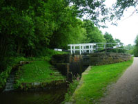
5. Huddersfield Narrow Canal Lock.
6. Bridge 73.
7. Railway Viaduct, 1849.
8. Ammon Wrigley's statue.
9. Wade Lock Tollhouse and board, 1881,
Saddleworth Museum Archives
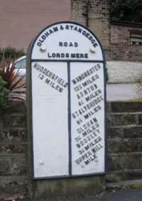
10. B & B Milepost, Oldham Road.
11. Waymark Capstone.
12. The Saddleworth Waymark - Crump,
Huddersfield Highways.
13. Morrismen.
14. Toll Board.
From the Saddleworth Museum car-park, walk north along the High Street, which is part of the Oldham - Standedge Trust Turnpike (1792), passing the Waggon Inn. Because travel by road was slow and difficult and better trade routes were needed, Turnpike Trusts were established by Acts of Parliament from 1706 to 1840s. Groups of local worthies raised money to repair and later to extend the highway network. Users were charged tolls to pay for the work. The name ‘turnpike’ comes from the spiked barrier at the toll-bar.
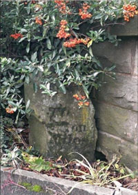
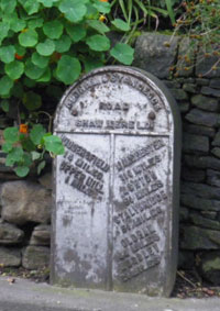
Continue over the River Tame and through the Square. Uppermill has a variety of lively shops, ranging from the downright practical through stylish to very quirky! Beyond the shops, cross the Kenworthy Gardens road and look carefully into the prickly hedge by the new wall. Under the vegetation, you will see a small old milestone that has been damaged, which shows Huddersfield and Ashton on its faces. 1
From 1767, mileposts were compulsory on all turnpikes, not only to inform travellers of direction or distances but to help coaches keep to schedule and for charging for changes of horses at the coaching inns. The distances were also used to calculate postal charges before the uniform postal rate was introduced in 1840.
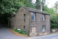
Continue along High Street past the Spiritualist Church; on the opposite side, on the corner of Ryefields Drive, you will see a house with a bricked up doorway. 2 This building had extra windows inserted when it was hired to become Brownhill Toll House in 1824. Closed in 1827and then re-opend in 1864 it was rented to take the tolls for the Turnpike especially from traffic entering Uppermill from the railway goods yard and new turnpike from Delph.
Continue under the magnificent arch of the railway viaduct (opened 1849) past the Brownhill Countryside Centre, which has a good selection of walks and other local information. Public toilets are located to the right.
At the roundabout, turn left along Dobcross New Road, passing the bus shelter. Cross over immediately and at the end of the bridge, turn right into Nicker Brow. This medieval cross-valley route led worshippers to the Saddleworth mother Church, St Chad’s, in Delph, founded 1215 in the ecclesiastical Parish of Rochdale.
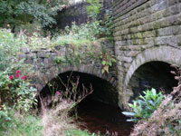
Look down to your right, in front of the late 18th century mill, and amongst the vegetation you will see the medieval packhorse bridge across Diggle Brook, jammed hard against the bridge of the Oldham & Ripponden Trust Turnpike Branch later extension (1864). 3 Goods were carried by packhorses though the Middle Ages and later, because the highways were not suitable for wheeled vehicles; usually a flagged stone causeway was the best surface, often with a sunken lane or holloway alongside, to permit passing. From 1555, the parishes and townships were made responsible for the maintenance of their roads. Individuals had to provide compulsory labour or a payment in lieu, the earliest form of ‘rates’ or council tax called the Composition.
Return to the roundabout and turn left into Wool Road. At this corner of the junction, over the wall, stood Brownhill Bridge Toll House built for this latest road and demolished c1960.
Continue up Wool Road until you reach the ‘Navigation’ public house car-park. Against the wall is a large cast-iron plate, a milestone made at Brayshaw & Booth’s foundry in Liversedge. 4 The foundry cast 600 milestones, mostly of triangular section as in the example further up the hill, for the West Riding County Council in 1893, well after the turnpike trusts had been wound up.
The original Oldham & Ripponden Trust Turnpike joined this road at the top of Wool Road with a chain bar.
Retrace your steps down Wool Road and over the canal. Looking right, you can see the Wool Road Transhipment Shed. This was used to take goods from Huddersfield Narrow Canal to the Turnpike for carrying by pack-horse over the Pennines whilst the 3 mile long tunnel was being built (1799-1811). Our walk returns to Uppermill along the canal towpath.
The Huddersfield Narrow Canal was begun with great optimism in 1794, to provide a link across the Pennines. Work camps were established at various strategic locations to house the numerous local labourers and craftsmen, the original navigators, later abbreviated to 'navvies'. A series of 74 locks along its 19.75 mile length raises the canal to a height of 645 feet above sea level, making it Britain's highest canal. 5 The Standedge Tunnel proved a formidable obstacle and Thomas Telford was appointed in 1806 to finalise the work. The tunnel was officially opened in 1811, allowing through navigation for the first time between Huddersfield and Ashton-under-Lyne. However, by 1844 canal freight rates had fallen such that it was uneconomical to continue and the canal was sold to a railway company, who utilised it to build tracks still in use today. The canal was closed in 1944 and re-opened in 2001 through the efforts of local enthusiasts: see www.huddersfieldcanal.com
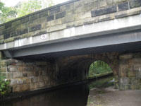
Continue a few yards to the public Car Park on your right. Walk across this to the Canal tow-path crossing the site of the huge warehouse built to attract canal traffic in the early 19th century. After about 100 yards you will walk under Bridge 73; half the underside of the bridge comprises modern steel girders, adjacent to the original turnpike bridge. 6
Continue along the tow-path, passing the Countryside Centre on your left. Just beyond Lime Kiln Lock is a path to the right that leads up to the Delph Donkey, an LNWR branch railway line to Delph which opened in 1851.
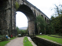
Continue along the tow-path under the viaduct towards Uppermill. 7 Notice the skewed stone work of the arch and the protruding corbels to support the construction platform.
As you follow the path you will walk between the canal and the river; look out for the stepping stones crossing the river and the modern spikey green sculpture sticking up from the foliage. When you reach Bridge 77, turn left from the towpath to the High Street. Turn right towards the museum, pass it and continue up Oldham Road.
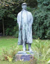
Just beyond the museum carpark is Wade Lock and a statue of Ammon Wrigley, local poet and historian. 8 Opposite the statue stood the Wades Lock Tollhouse, 9, now demolished.
As you climb the hill the first house of the pair was rented as the toll house to catch traffic at the south end of Uppermill, opened in 1864. If you continue about 100 yards further up Oldham Road, you will see a smaller Brayshaw & Booth mileplate outside No. 38. 10
Then retrace your steps to the carpark. To view an extended original tollhouse, drive to Greenfield, where you will find Frenches Toll House on Chew Valley Road.
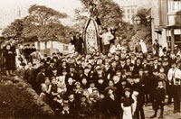
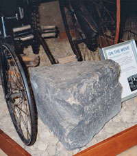
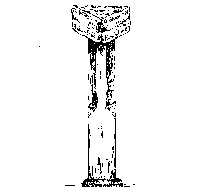
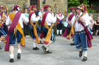
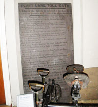
Do take some time to visit Saddleworth Museum and Art Gallery, www.saddleworthmuseum.co.uk, well worth the small entry fee. Amongst the exhibits is the capstone 11 of the 1750s Saddleworth Waymark, 12 which originally stood where the Standedge Road joins the A62 Huddersfield Road. The story told is that young men returning from a night out would challenge each other to lift the capstone onto the nearby wall and back again; apparently only one man was able to accomplish this! Saddleworth is also famous for its rush-cart procession, with its convivial morris dancers. 13 Another exhibit is the Platt Lane toll board, showing the rates for each class of vehicle and animal. 14 The width of the wheels or fellies also determined the amount due, because narrower wheels caused more damage to the road surface. There is also an unusual “Take off here” stone, indicating when the additional horse required to help pull a coach or wagon up the hill should be removed.
Uppermill has a large number of pleasant cafes, tea-shops, ice-cream parlours and public houses providing refreshments.
We hope you have enjoyed this historical stroll, originally devised by Chris Marcus for The Milestone Society and revised by Alan Schofield, Saddleworth Historical Society, www.saddleworth-historical-society.org.uk
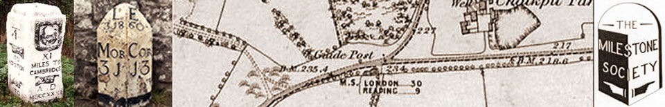
The Milestone Society was established in 2001 to campaign for the conservation of milestones and other waymarkers, which are endangered by neglect, by vandalism and by casual destruction. You can find out more about our work plus details of the c 9000 milestones in the UK by visiting our website, www.MilestoneSociety.co.uk
While care has been taken to ensure the information above is accurate, the Milestone Society accepts no liability for any claim, loss, damage or injury (howsoever arising) incurred by those using the information provided. Please ensure that you wear suitable footwear and always carry a drink and a snack.
CLICK HERE to download a PDF to print out this walk