HIGHWAYS HERITAGE WALKS
Milestones and boundary stones in Oxford
Walk Length: a circular walk of approximately 5 ¼ miles (can be shortened by around 1 or 2 miles) Full walk approx. 3 hours including pauses to view historic features.
Grade: easy; mostly flat; one easy ascent and descent; all on tarmac or concrete except sections 5 and 6 on gravel paths. The route is mainly suitable for wheelchairs but some modest detours are necessary in three sections because of steps and kissing gates, shown in green below.
Start: St Clement’s car park, off St Clement’s Street, Oxford, OX4 1AB
Grid Reference: SP 5240 0605
Travel and P&R parking: Arriva 280 bus to Aylesbury from Oxford Railway Station, or towards Oxford from Aylesbury, Thame and Wheatley, every 20 minutes, journey time from railway station 10 minutes). For more distant visitors travelling by car or express coach from London, use 400 bus from Thornhill Park & Ride off A40 at Headington; from other directions, use 400 bus from Seacourt Park & Ride off A34 (western by-pass), through the city centre (running every 12-15 minutes, journey time 15 minutes). Alight at the St Clements bus stop.
Parking: in St Clements car park (but read the additional note at the end about parking and accommodation)
Description
Part semi-rural, part ‘Arcadian’, part inner urban near the city centre. For those generally familiar with Oxford, the walk offers a considerable variation on the routes used by other general and themed guided walks (which abound) and identifies items very largely unknown and unseen even by long-standing city residents. For those new to Oxford, it provides a good introduction to the city, eleven waymarkers of historic interest and glimpses of a host of well-known landmarks that might encourage a further visit. The route includes 17th century ‘milehighway stones’ (almost unique to Oxford), 18th century milestones, a 19th century tollhouse; and parish, hundred, ward and county borough boundary stones.
The walk is divided into seven sections. Section 2 can be omitted to reduce the length of the walk by about one mile. Replacing section 5 with 5a and omitting 6, shortens the route by a further mile.
Section summaries are as follows:
Section 1: St Clements to Cuckoo Lane (linear); 0.7 miles; one 19c parish boundary stone, one 17c highway stone
Section 2: Cuckoo Lane to Pullens Lane and return (circular); 1.2 miles; one 18c highway stone, one 18c milestone, two 19c boundary stones
Section 3: Cuckoo Lane to Parks Road (linear); 1.0 mile; one ward boundary stone
Section 4: Parks Road to Turl Street (linear); 1.0 miles; two 19c(?) hundred boundary stones, one 18c milestone
Section 5: Turl Street to Folly Bridge (linear); 0.8 miles; one 19c tollhouse
Section 5a: Turl Street to Rose Lane (linear) 0.6 miles
Section 6: Folly Bridge to Rose Lane (linear) 0.9 miles;
Section 7: Rose Lane to St Clements (linear) 0.5 miles; one 18c milestone
Health and safety
Much of this walk is along car-free paths and lanes. However, bicycle lanes and, in a city with two universities, unpredictable cyclists are a hazard. Most of the recommended main-road crossing places are by pedestrian crossings or traffic lights, observed by cars and buses but not universally by cyclists. Be particularly aware when crossing roads with cycle lanes.
The walk can be undertaken at all times of year and in all normal weather conditions, but is best between April and October. In late autumn and winter some of the paths may be leaf-strewn and slippery when wet. In or after heavy rain, the gravel paths can become muddy with puddles. The route passes through the University Parks and Christchurch Meadow, whose gates are locked around dusk. Prominent notices display the closing time. Make sure to allow enough time to exit on foot from the park and meadow before the gates are locked. Otherwise the only exit is by swimming!
Refreshments
The full walk may be split into two roughly equal parts, stopping for refreshments about half way. After approximately two and a half miles, a very slight detour leads into an area of the University Parks liberally provided with seats and benches, an idyllic spot for a picnic in clement weather. A few hundred yards further on the walk passes a well-known pub, serving traditional pub food. There are many other pubs along the way, and two at the start/finish. There are public toilets at the start/finish and in section 4.
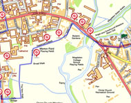
1 Boundary stone
2 Cherwell St
3 St Clement'st
4 Islamic Centre
5 Mileway and highway stone
6 Boundary stone
7 Modern Sculpture
8 Bridge
9 Second highway stone
10 Small plaque
11 Well preserved milestone
12 Boundary stone
13 Plaque
14 Boundary stone
15 Kingsmill House
16 Griffin on roof
17 Hundred stone
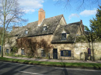
18 Old cottage
19 Lamb and Flag passage
20 St Giles Churchyard
21 St Aloysius RC Church
22 Milestone
23 Hundred boundary stone
24 Broad Street
25 High Street
26 Back of Town Hall
27 Christchurch meadow
28 Alice's shop
29 Tollhouse
30 River Isis
31 Merton College Tower
32 Morse's walk
33 Aeronaut
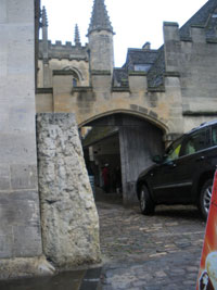
34 Magdalen Gatehouse
35 Magdalen milestone
36 Magdalen Bridge
Route Instructions
SECTION 1.
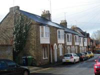
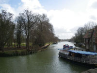
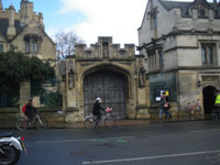
Leave the car park via the pedestrian lane between the coffee shop with the Angel and Greyhound pub on your right. Turn left into St Clements (a busy main road). You are now near the start of the Oxford-London stretch of the ‘Great Road’ from London to Worcester, turnpiked in 1719. After a few yards, cross at the traffic lights and turning left, continue along St Clements. After some 200 yards, passing the ‘Hospital for the Poor’, stop just before the bus shelter and look behind the unhelpfully placed lamp-post for 1. (SP 5266 0698) a boundary stone. Nothing can now be deciphered but it is inscribed CSJD 1858, and marks the boundary of the ancient parish of St Clements with the (then) new ecclesiastical district of Cowley St John. Note the unusual reddish-colour stone, not a local stone. Then cross at the traffic lights to London Place and turn right, passing a terrace of Regency houses. Ahead of you the present A40 ascends Headington Hill. A little way up the hill but out of sight, the original route of the Great Road branched to the right up Cheney Lane into the suitably named ‘Old Road’ before climbing the long, steep gradient of Shotover Hill. To avoid the steep climb, a new turnpike road was created in the later 18th century up the shorter Headington Hill.
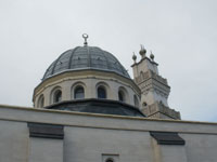
Bear left along Marston Road. As you cross Cherwell Street, glance down it at the ‘gothic’ houses with upper bay windows, 2 then pass tranquil St Clements Church 3. At the majestic Centre for Islamic Studies 4 cross the road to the lane opposite, Cuckoo Lane..
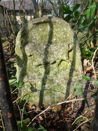
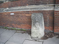
On the left side of the lane 5 (SP 5287 0663) is one of Oxford’s four mileway and highway stones dating from the 17/18th century. (Very few exist anywhere else in England.) Under an Act of 18 Elizabeth, everyone who occupied land within five miles of Oxford was bound to contribute to the repair of the roads within one mile of Oxford, and supervisors were nominated by the Mayor and Vice-Chancellor for the executing of the repairs. The mileways were measured from the city gates, in this instance the East Gate (see section 5a). This stone, however, records the end of the Headington Highway, the stretch immediately beyond the mileway, which is perhaps why the inscription is on the back of the stone. Now badly weathered, it probably originally read ‘Here Endes Hedington Way’. Before the building of the ‘New Road’, Headington Way was the chief road between Oxford and what is now Old Headington but early maps show it branching off Headington road to the left, not Marston road, so the stone’s current location at the end of what was never shown to be a road is puzzling.
SECTION 2.
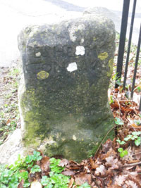
Walk up Cuckoo Lane. After about 200 yards, look to your left for the boundary stone, 6 (SP 5307 0668), behind iron railings in bushes and next to a tree. The stone is rather worn and hard to read in the shade but you should be able to see the Ox and the wavy lines denoting the ‘ford’ and possibly the legend “C.J.S/ MAYOR”. This stone marks the new eastern boundary of Oxford in 1835. The initials stand for Charles James Sadler (Mayor in 1836/7) This design was regularly used for the city boundary stones. After about another 100 yards turn right up steps into Headington Hill Park. Once the “most grandiose council house in England”, rented for a pittance by Robert Maxwell, it is now part of Oxford Brookes University.
Note: wheelchair users carry on up Cuckoo Lane to the junction with Pullens Lane, turn right and follow the lane to Headington Road, rejoining the walk at ** below.
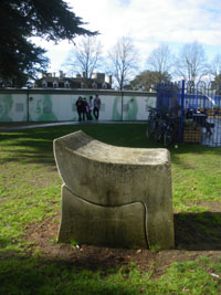
Follow the path as it turns uphill, then follow the signs for ‘Willow Building’, up a flight of steps and along the side of the long white building; follow the path past the blue railings and modern sculpture 7 and turn right at the junction, then after 50 yards go through the gate onto the bridge over Headington Road. 8 Stop before the end of the bridge and look to the left down at the road. On the left-hand side uphill, 5 yards beyond the lamp-post, a second highway stone is set into the wall. 9. (SP 5328 0649) Binoculars are needed to read the legend, which states: ‘H E R E E N D E T H /H E D I N G T O N H Y W A Y /W K I F’ The stone probably dates from 1729, and was moved from the top of the hill to this position in 1930. WK and IF are probably the initials of William Kenton and Jeremiah Frankllin, who were Senior Bailiff and Mayor of Oxford in 1728/9 respectively.
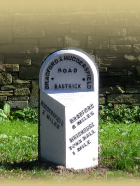
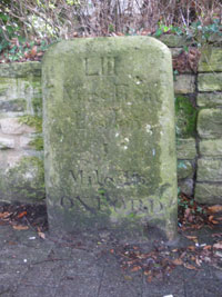
Return across the bridge, turn right between the black railings, follow the pathway leading down to the pavement, and turn left along Headington Road. ** Continue to the entrance to Oxford Brookes Headington Campus and note a small plaque 10 in the flowerbed, recalling the NUJ members who picketed Robert Maxwell’s premises from 1989 – 1992. Cross the road at the refuge and continue to No 186, where a large well preserved milestone stands against the wall. 11 (SP 53440 06580). The legend reads: ‘LIII/ Miles From/London / I Mile/ To OXFORD’. This stone, and others in the same series, were erected in the late 18th century. All were of limestone, probably taken from the nearby Headington quarry. The shape of the stones vary. This one is more rectangular than most, which are usually rounded at the top and often tapering. See http://www.headington.org.uk/oxon/streets/
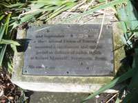
Return to the refuge, cross over, and walk down Pullens Lane (to your right) to its junction with Cuckoo Lane and the boundary stone 12 (SP 5328 0652) a superior version of the standard design, marking the 1901 county borough boundary. The well-preserved legend reads: 1901/[City coat of arms: ox crossing ford]/C. G. D R U C E/ M A Y O R/—/J. D O R N E/ S H E R I F F’. Mayor of Oxford in 1900/1 is an interesting man, whose career is detailed in the website www.headington.org.uk/oxon/mayors There is also a stone plaque 13 commemorating ‘Joe Pullen’s Elm’ in the wall to your right. Pullen was Vice-President of Magdalen Hall (then still situated in the grounds of Magdalen College) for 57 years, from 1656 until his death. He was responsible in around 1700 for the terraced footpath on the north side of Headington Hill. It was paid for by a general subscription of the University: hence the joke that Pullen had “made a-way with public money”.
Walk left down Cuckoo Lane back to the junction with Marston Road.
SECTION 3.
Turn right and cross Marston Road to the sign ‘Access to Kings Mill only’ and turn down the footpath signed ‘to the University Parks’.
Wheelchair users have a choice of two routes, 3A or 3B. 3A requires only a slight detour and has a smooth, firm surface the whole way. 3B is rather longer and partly along unmade lanes but is more scenically interesting with the bonus of passing an additional and unusual boundary stone not on the route of the main walk.
3A: continue east along Marston Road for 350 yards, then turn left into Ferry Road. Follow Ferry Road to the end and turn left on to the combined cycle/pedestrian park. Follow this path for about half a mile until it joins up with the main route at the large weir.** Be aware that this path carries quite heavy and speedy two-way bicycle traffic.
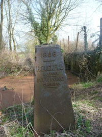
3B: continue east along Marston Road for 400 yards, then turn left into Edgeway Road. Continue for approximately 350 yards to the end of the road, cross a cycle way and carry straight on for about 700 yards along an unnamed tarmac road, with various college playing fields and sports pavilions on your right, continuing to follow the road as it becomes an unmade up lane with a slightly uneven surface until you reach a gate – wide enough for wheelchairs. Shortly after the gate, by a low bench, turn left along a lane into Marston Meadows. After three hundred yards just after a weir, there is a boundary stone on your right 14 (SP 5200 0753). The legend, which is easy to read is:
“1886/ R. B U C K E L L M A Y O R/ F. T W I N I N G S H E R I F F
This boundary marker is atypical as it has a concrete core, which you can see protruding at the top, encasing cast-iron sides and lacks the standard design Oxford crest. It also differs from the standard design by having taping sides and front.
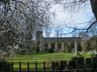
From the boundary marker continue for about 150 yards to the hump-backed Rainbow Bridge, which leads from Marston Meadows into the University Parks. A few yards after the bridge turn left and follow the path that runs beside the Cherwell river. After about 300 yards, take the right fork. This brings you into the recommended picnic area of the main walk. Follow the path round to the right; after about 120 yards it emerges into a road by a small roundabout; bear left and emerge into South Parks Road. (The total distance of this detour, from the Islamic Centre to South Parks Road is 1.35 Miles)
Walk down the footpath, with the Islamic Centre on your left. After about 90 yards cross the bridge through the gate where the mill weir joins the river and look to the right for the boundary stone against the wall of Kingsmill House. 15 (SP 526 066) This marks the Ward and Union boundary and probably dates from 1842. The legend, best read with binoculars, reads: ‘J. W Y A T T/ M A Y O R/W A R B U R T O N /S H E R I F F’. James Wyatt was Mayor in 1842/3.
There is also a benchmark on the wall nearer the weir paddles.
The King’s Mill stood here by the Cherwell until 1832. Headington was a royal manor from at least the reign of King Elthelred c.1000 AD who had a residence there. Domesday Book records two mills in 1086. Anthony Wood wrote in the seventeenth century, “Kings Mill, soe called perhaps from King Ethelred that lived sometimes at Hedindon”.
Stay on the path and enter ‘Mesopotamia’, so called because of the two parallel branches of the river Cherwell, a small-scale imitation of the rivers Tigris and Euphrates in Persia. Follow the leafy path across a number of bridges, keeping straight on for approximately half a mile; the path turns left over a curved bridge, then turn sharp right, through a gate and pause to watch the Cherwell frothing over a large weir. **
You can follow either the pedestrian/cycle path to the left, or walk parallel along the grassy track beyond the railings, rejoining the cycle track at a bridge. Cross the bridge; for a picnic break at this halfway point, turn through a gate on the right into the University Parks where there are plenty of benches.
Otherwise, carry on along the path, which emerges at the junction of St Cross and South Parks roads. Cross over to the pavement on the left-hand side of South Parks Road. Walk along this road, over Mansfield Road through the University Science area 16 to the junction with Parks Road.
SECTION 4
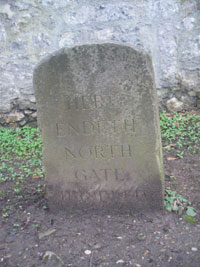
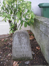
Turn left into Parks Road; cross the road at the traffic lights, walking left down Parks Road as far as the Hundred Stone 17 (SP 5148 0670), opposite an old cottage 18 and in front of the high stone wall of St John’s College gardens. The legend reads:
‘H E R E /E N D E T H /N O R T H /G A T E /H U N D R E D’.
The date of this stone is uncertain, probably a 19th century replacement of an earlier stone. It marks the northern boundary of the Northgate (or Oxford) Hundred and the start of the Bullingdon (or Headington) Hundred. Hundreds as administrative units date back to the Anglo-Saxon era and were still in use in the 19th century, for example to define Poor Law Workhouse areas.
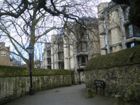
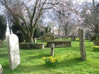
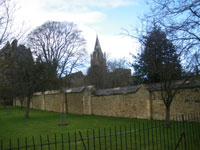
Turn and retrace your steps back along Parks Road, staying on the left-hand pavement, pass the traffic lights and turn left into Museum Road, looking across to the Museum of Natural History to the right, with its dinosaur footprints in the forecourt. Looking to your right, you can see the red brickwork of Keble College, the only college built in Victorian times. At the end of this road, continue down the footpath leading to Lamb and Flag passage, with its severe modern buildings on the left. 19 For a refreshment break, enter the Lamb and Flag pub. Otherwise, carry on down the passage and turn right into busy St Giles, often crowded with tourists. Walk past the War Memorial and cross the Banbury Road, turnpiked in 1755, at the pedestrian lights. Walk straight ahead through St Giles’ churchyard 20 to Woodstock Road, the continuation of the Great Road.
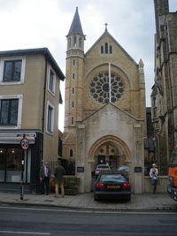
Turn right and walk up Woodstock Road. By St Giles Church Hall, opposite St Aloysius RC Church 21 at the 20/30 speed limit sign, is a milestone 22 (SP 5100 0701) [3.4 miles]. This is ‘London 55’, so badly degraded as to be indecipherable. All the inner city milestones have suffered badly in recent decades from pollution and neglect.
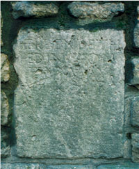
Turn back along Woodstock Road; cross the road at the traffic lights and continue left along St Giles. At no. 42 is another hundred boundary stone. 23 (SP 5240 0605) [3.5 miles] The legend is the same as the stone in Parks Road. The English Heritage listing describes this stone as ‘ancient’ (and the other as ‘modern’) but this one too is more likely another 19c replacement of an earlier stone. The history of the expansion of the city boundaries and its internal divisions is extremely complicated. For information about Northgate Hundred see www.british-history.ac.uk/report.aspx?compid=22807
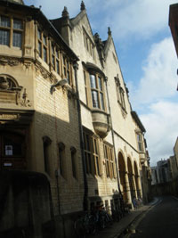
Carry on down St Giles; cross Beaumont Street at the traffic lights (Ashmolean Museum on the right) into Magdalen Street. Immediately cross the road at the traffic lights, walk past the Martyrs Memorial; cross the short bus-only road, Magdalen Road East, and turn right, taking extra care if there are crowds of tourists as well as careless cyclists. Follow Magdalen Road East to the junction and turn left into Broad Street,24 crossing to the far side (a pedestrian zone but beware bikes). Walk along Broad Street and turn into the first road on the right, Turl Street. Follow Turl Street to the end at the junction with High Street. Exeter and Lincoln Colleges on the left, Jesus College on the right.
(To shorten the walk, missing the tollhouse, follow the route for section 5a, rejoining the full walk at the start of Section 7.
SECTION 5A.
Turn left down the High Street (busy pavement) past Brasenose College on the left, Oriel College on the right, University Church of St Mary and All Souls College on the left, University College on the right, Queen’s College on the left and Examination Schools on the right. Cross Longwall Street at the traffic lights. Continue down the High Street. Just past the junction with Merton Street on the right is the Eastgate Hotel, site of the former East Gate. Continue as far as Magdalen College Porter’s Lodge, opposite Rose Lane.
SECTION 5.
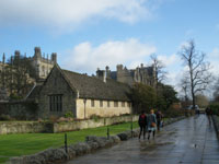
Turn right up the High Street 25 to cross over at the traffic lights; turn back left and then right (by the NatWest Bank) into Alfred Street. At the end of Alfred Street turn right into Bear Lane; continue along Bear Lane into Blue Boar Street (a narrow sloping pavement) passing the ornate back of the Town Hall, 26 to the junction with busy St Aldates. This is the Oxford to Abingdon road, turnpiked in 1756 and part of an Anglo-Saxon road running from Southampton to Northampton. Walk left down St Aldates, past Christchurch College and its memorial meadow 27. Across the road is Alice’s Shop, featured in ‘Alice in Wonderland’, 28 but there is no sheep serving at the counter today!
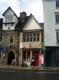
Cross the road at the traffic lights at the junction with Thames Road, and continue along St Aldates. Cross Thames Street and continue to the Tollhouse just before Folly Bridge 29. (SP 5142 05610) Rebuilt in 1826, this is the only remaining tollhouse of the three previously near the city centre. The Banbury Road tollhouse still exists but is two miles from the centre, as was the now-demolished Woodstock Road tollhouse. Now a small general store, it is in need of some TLC.
SECTION 6.
Enjoy the view from Folly Bridge over the river Isis (Thames); to cross the road safely, walk over the bridge to the traffic lights in pre-1974 Berkshire. Turn back over the bridge, looking down 30 at the punts moored above the bridge, pass the Head of the River pub, and immediately turn right and walk through the pub car park down to the riverbank; cross the bridge at the end, through the kissing gate on to the gravel path alongside the Isis. Wheelchair users should return along St Aldates, turning right into Blue Boar Street and Bear Lane. Follow Bear Lane into Oriel Square (Oriel College opposite). Bear right and then left into picturesque, cobbled Merton Street, past Corpus Christi and Merton Colleges on the right and the real tennis court on the left. Near its end Merton Street swings round to the left to meet the High Street by the Eastgate Hotel. Turn right and follow the High Street to the junction with Rose Lane and rejoin the main route at **
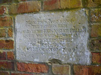
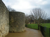
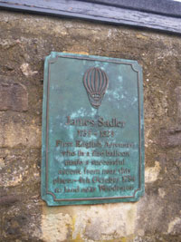
Stroll along the riverbank to the end of the railings, watching ducks, swans and grey geese bobbing and, in the summer, much boating activity. Turn left and walk up a wide tree-lined gravel track towards Christchurch as far as Christchurch archway. Turn right and walk a short distance (80 yds) along the Broadwalk. At the end of the stone wall, turn left towards Merton College Tower, 31 between Christchurch gardens on the left and playing fields on the right. Just before the next kissing gate turn right on to Dead Man’s Walk, alongside the most extensive remaining stretch of the old city wall. Dead man’s walk is so named because it was the route taken by funeral processions from the Synagogue to the Jewish burial ground. This was on the site of the Botanical Gardens, see section 7. Continue along Inspector Morse’s favourite route, 32 noting the plaque set in the wall 33 to commemorate Aeronaut James Sadler, to the next junction and turn left along the path that leads through a kissing gate to Rose Lane. Walk down Rose Lane, passing the back of Merton College, to the junction with the High Street **. Cross the High Street, using the refuge to your right, to Magdalen College porter’s lodge 34 and continue forward.
SECTION 7.A few yards along the High Street by the base of Magdalen College Tower, a milestone abuts the face of the tower at the entrance of the short cobbled lane leading down to the punt station. 35. (SP 5210 0614). This is ‘London 54’. The stone is considerably weathered but the first two lines of the legend can still just be read: ‘LIV/ MILES/ from/ London‘
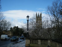
Continue to the end of the High Street (Botanical Gardens on the right) crossing the Magdalen Bridge 36. The roundabout at the Plain, with its clocktower and three main roads leading off it, is the site of the former St Clements tollhouse. This served two turnpike roads. The right-hand road, the Iffley Road, turnpiked in 1736, is still an alternative route to London via Henley-on-Thames. The centre road, the Cowley Road was never turnpiked. The left-hand road, St Clements, is the route of the Great Road from London to Worcester, turnpiked in 1719. Follow the St Clements road. The second turning on the left (before the Angel & Greyhound pub) leads into the car park and marks the end of the walk.
Car-parking and accommodation in and near Oxford
Car-parking and accommodation in central Oxford are both limited and expensive. St Clement’s car park, (currently £6.50 for 3-4 hours, £9.50 for 4-6 hours) is small and, if a planning application is successful, will become even smaller, and perhaps temporarily moved elsewhere. Visitors are recommended to use the Park & Rides or public transport as described above. Thornhill Park & Ride is used by commuters to London as well as Oxford visitors and is often full before 9am so it is best to use public transport to reach it.
Accommodation is cheaper outside Oxford. Convenient accommodation is to be found at the Travel Lodge at Wheatley, some 6 miles from central Oxford. This is easily found and a few minutes drive from the M40, junction 8A southbound and 8 northbound. Follow the signs to Oxford, then Wheatley. Do not turn on to the A40. The Travel Lodge and an adjacent Harvester Inn are on the left shortly after crossing Wheatley Bridge. An Asda supermarket is also close-by with the cheapest fuel in the area (credit card payments only). The 280 (request) bus stop is just beyond the Travel Lodge. Wheatley village, about half a mile away is interesting, and includes a milestone on London Road, which was part of the original route of the Great Road, and a pyramid-shaped lock-up for drunks. See http://en.wikipedia.org/wiki/Wheatley
The Milestone Society, established in 2001, campaigns for conservation of milestones and waymarkers, which are endangered by neglect, by vandalism and by casual destruction, and aims to share our interest in these fascinating pieces of history.
You can find out more about our work plus details of more than 9000 milestones in the UK by visiting our website, www.MilestoneSociety.co.uk
While care has been taken to ensure the information above is accurate, the Milestone Society accepts no liability for any claim, loss, damage or injury (howsoever arising) incurred by those using the information provided. Please ensure that you wear suitable footwear and always carry a drink and a snack.