HIGHWAYS HERITAGE WALKS
Waymarkers of the Peak District
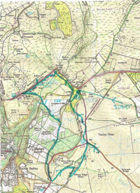
Walk Length: 5.5 miles
Grade: Moderate – the route mainly follows good tracks and trails around the National Trust’s Longshaw Estate, located within the Peak District National Park – the first in England, opened in 1951- but includes short sections of rough moorland, including one short but steep path. The walk takes in high moorland and walking boots or stout shoes and rainwear are recommended.
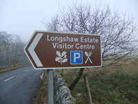
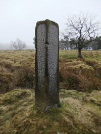
Start: Longshaw car park (Woodcroft, free to members, otherwise pay and display). From Sheffield and North, turn right off Hathersage Road, A1687, at Fox House Inn onto Owler Bar Road; the NT car park is well signposted, about 200 yards on right. 1 (signpost)
Grid Reference: SK 267800
Postcode: S11 7TZ
OS Maps: Outdoor Leisure 1- The Dark Peak area and OL24- The White Peak area
Facilities: There is a National Trust café, shop and visitor centre (weekends only in winter) together with public toilets (open daily all year) on the route. Nearby is the Fox House Inn, open all day and a popular place to eat or enjoy a drink. A second much visited pub, the Grouse Inn, is passed on the walk
Public transport: There is a frequent (3 times an hour) bus service from Sheffield to Fox House, a short walk from start point
Description
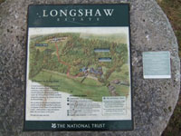
The route visits 5 mileposts, 2 boundary stones and 3 ancient gritstone guide posts (known locally as ‘stoops’, derived from an old Scandinavian word) used by packhorse trains before the turnpike era. Each stoop is accompanied by a ‘companion stone’, part of an art project instituted in 2010. The walk also takes in a prominent wooden pole also once used as a guide to travellers and parish boundary marker. The route is around the spectacular Longshaw Estate, formerly the hunting ground of the Dukes of Rutland. There are good paths but also sections of rough ground walking and of course some sections beside busy roads (a high visibility vest is recommended for your safety). The area is a very popular tourist attraction set in the spectacular scenery of the Peak District National Park and can be very busy on summer Sundays and Bank holidays. 2. (Map board)
1 Signpost
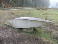
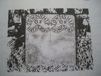
2 Map
3 Map
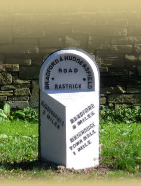
4 Milestone
5 Guide stoop
6 Milepost
7 Gritstone guidestoop
8 Modern companion stone
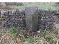
9 Square stone post
10 Companion stone
11 Guide stoop
12 Remains of Lady’s Cross
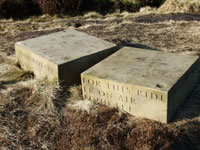
13 Calver to Gleadless milestone
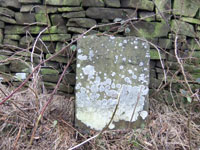
14 Elegantly carved boundary stone
15 Elegantly carved boundary stone
16 Tall pole
17 Boundary stone
18 Milestone
19 White painted milestone
Route Instructions
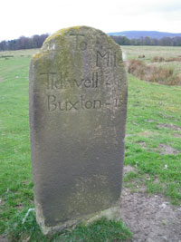
3 From the car park, follow path towards Visitor Centre and at path junction fork right along the drive- i.e. away from Visitor Centre. Look to your left along this drive and there’s a stone visible in the meadow a hundred yards or so away 4 This milestone is not accessible to the public; it show distances to Tideswell (8 miles) and Buxton (15) on one face, with the other showing Sheffield, but very indistinct. The remote location shows how the routes have changed in the area over the years. Carry on along the drive and as you approach the gates, your first guide stoop is on the left. 5
The stone has been moved and was put on its present site in the 1960s, by the NT, as close as possible to its original location. However, it’s 90 degrees out of alignment.
Guideposts were required by an Act of Parliament of 1697 and many of the posts in this area date from 1709, when a reminder was issued to Parish Surveyors by the justices at the Quarter Sessions in Bakewell.
This particular post, though, bears a date of 1737. Some were carved by those unskilled in layout or spelling, as in this case. We have directions to ‘Sheif-field Rode’ –i.e. Sheffield Road, ‘Hope Rode’,’ Dronfield Rode’ and Tidswal Rode’- i.e. Tideswell. There are 7 or 8 different spellings used for Sheffield and for Chesterfield Located close to the stoop is its ‘companion stone’. This is one of 12 stones erected around 2010 by Arts in the Peak and you will have the opportunity to see two more of them later on your walk. Each stone bears an inscription, but relating to the future rather than a local market town. Read more about the Companion Stones Project at www.companionstones.org the site also includes some information about the original stoops - click ‘extra’ then ‘guidestoops exhibition’
Go through the gates and cross the road with care, taking the stile opposite then follow the path signed to Barbrook Bridge. Keep left and onto the wooden footbridge over Bar Brook. Immediately over the bridge, turn left and immediately leave the main track and take an indistinct path veering right (at about 30 degrees to main track) and head towards the gate. As you approach this, you have a choice of continuing over the rough grass or going through the gate, turning left along the footway, for about 500 yards to the next milepost. If you stay with the grass, note it can get a little rough and wet, but it’s quieter than the roadside. Follow the line of the fence - you can choose your precise route over this open access land – until you come level with the second stile, ignoring all gates up to then. Cross this and turn right to the milepost close by. 6
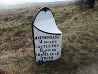
This attractive cast iron post – showing distances to Sheffield and Hathersage, Castleton, Chapel en le Frith is one of several similar posts still in place along the A6187. It dates from around 1840.
Return to the stile, cross over and turn right, till you meet a clear track– Hollowgate, an ancient packhorse route over the moors (or you can follow footway by the roadside to the point where the way meets the road at a signpost and gate below). Turn left and follow this track down to the stream - enjoy the fantastic shapes of the weathered stones - cross the bridge and climb up to the road.
Take the path on the opposite side of the road.
There are seats by the old barn, now restored and displaying information about the area, so it’s a good place to pause and enjoy the splendid views. There are also millstones around, a reminder that manufacturing these was once a very important industry locally.
Follow the clear track and pass the lake. At the end of the lake there is a footpath sign to Yarncliffe. Ignore both Yarncliffe and main paths and at this point go straight ahead along a narrow track, making for the small gate into the plantation. Go through and follow the faint path through to a gate at the other side. Ahead and slightly right, you can see the next of our gritstone guidestoops. 7 Make for it, but watch out for the several very small streams hereabouts.
This prominent stoop is dated 1709. It’s hard to imagine that this was once on an important trade route, with strings of packhorses bringing many goods, but especially salt from Cheshire, over to the towns of South Yorkshire and Derbyshire. The routes were mainly used only in summer months, as the changeable weather conditions hereabouts would make them a dangerous place to be in winter. The destinations are fairly distinct - -‘Shafild’ ‘Chasterfild’ and ‘Tidswel’ will present few problems, but side 4 –‘to Hatharsich and so to Chapil in lee Frith’ will really baffle, not least because of the unusual layout to fit the slender post!
Walk forward towards the large stone gateposts about 100 yards ahead and slightly right, avoiding boggy areas as you do so.
Just beside these is the modern companion stone to the stoop you have just left. 8
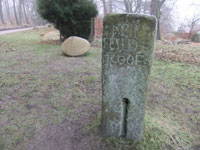
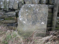
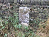
Turn right along the broad and level track for about half a mile, following it until the conifer trees thin out and there’s a cross path – go left on an indistinct path up the hill, for a few yards to the road. Turn right down the road. After about 150 yards, look across and where the wall rises on a bank (with a large silver birch tree behind) there is a square stone post by the wall. You need to look carefully, as in summer the brambles may be a bit rampant. Cross the road with care if you want a closer look. 9
The stone is of an uncommon design, though unfortunately weathering has left little of the inscription (Gleadless 11, Calver 3) to be seen. It is on the Gleadless to Calver Turnpike and dates from about 1781.
Carry on down beside the road, passing a National Trust gate on the left, and the Grouse Inn soon comes into view on the right. Just before the inn, at the wooden bridleway sign on the left, take the path across the field, then up to a T-junction. At this point there is the option of going right, on the rough track up the hill (signed White Edge), to see a splendid guide stoop. Alternatively, you can shorten the walk by a little over half a mile and turn left (signed Longshaw)
To visit the guide stoop, go up the hill on the rather rough path and follow the clear route beside the wall, turning right at the next signpost (towards Curbar Gap) when you get to the top. This is a wonderful path along White Edge, one of several escarpments that are characteristic of the area. Follow this path for about 10 minutes. Keep your eyes open for a companion stone beside the path on your left 10 (so save the views over the edge till your return journey!) - from the companion stone, look back left over the heather and the guide stoop stands out about 75 yards away. 11 Leave path and make your way across the heather.
Again, all signs of the long lost moorland pack horse ways are gone and it’s easy to see what a welcome sight this now lopsided post would have been to the travellers across this wild and open moorland. The post bears a 1709 date and shows the way to Sheffield, Dronfield, Bakewell and Tideswell.
Retrace you steps along the path on White Edge and at the sign and junction ignore the path you came up earlier and head straightforward on the broad path. This is clear throughout and sometimes the dark peat can be muddy. When you reach a gate, go left and down the hill
More adventurous walkers can first follow the footpath to right over the moor and after a fairly short distance will find the remains of Lady’s Cross 12 in the heather, just right of the path. This was another way marker and the stump bears a date of 1618. This stone is shown on the Ordnance Survey map and is close to a public footpath. Please note that although several other paths used on the walk are not shown on the map, they are freely available for walkers to use
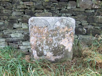
At the foot of White Edge both the shortened and this route meet – follow the path to the right of the lodge (now an NT holiday cottage, formerly a gamekeeper’s cottage), join the broad track and follow it to the road. Turn right along the verge and after about 300 yards, there’s another of the Calver to Gleadless milestones by the wall- and this time it’s a little more legible (Gleadless 10, Calver 4) than the previous one. 13
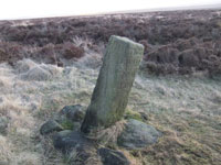
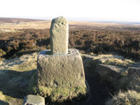
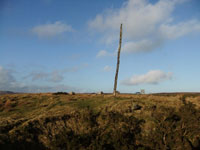
Retrace your steps to the road junction crossing over the road to walk on the verge facing the traffic. Opposite the grassy triangle, there’s an elegantly carved, though faded, boundary stone by the wall showing the townships of Holmesfield and Hathersage. 14 & 15 Then choose a safe place to cross back over the road- your target being the white gate on the corner in front of Wooden Pole. Go through the gate, leave the broad green track and walk right up to the tall pole. 16
Wooden Pole is a prominent landmark that served both as a way-mark and parish boundary marker – for Holmesfield, Hathersage and Totley parishes. The carved letter T and date of 1778 in the stone at the foot of is believed to mark the beating of the bounds of Totley parish at that time. A similar pole at nearby Stanage Edge is known to have been in existence since at least 1550 and it’s possible that this form of highly visible marker post represents the earliest method of guiding travellers over the moors
Head for the wall and lay-by just over it. Ignore the exit point and follow the wall side over the grass to the next gate. Turn left along the verge and you soon come to a prominent boundary stone 17 and a hundred yards or further on, a milestone. 18.
The boundary stone marks the boundary of the City of Sheffield and County of Derby. The milestone, which again has lost most of its inscription which originally showed ‘Bakewell 8 ½ , Sheffield 8, and is quite different from other mileposts in the area.
Continue in the same direction for a few yards to the next access gate and take a grassy path straight ahead. This soon reaches a viewpoint, known as Lords Seat. The path continues, descending the slope and down stone steps to reach a drive. Turn right along this and return to the Visitor Centre and your starting point.
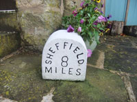
If you visit the Fox House Inn, you will find there’s a white painted milestone in the rear courtyard 19. Unfortunately it’s a fake!
With thanks to David Blackburn for devising this walk. For more information about the guide stoops in the area – there are several more besides those encountered on the walk - there is an excellent book available – “ Guidestoops of Derbyshire”, by Howard Smith. Landmark Publishing Ltd, ISBN-10: 184306426X . Available via Amazon or direct from the author on howard-smith@sky.com
The Milestone Society, established in 2001, campaigns for conservation of milestones and waymarkers, which are endangered by neglect, by vandalism and by casual destruction, and aims to share our interest in these fascinating pieces of history.
You can find out more about our work plus details of more than 9000 milestones in the UK by visiting our website, www.MilestoneSociety.co.uk
While care has been taken to ensure the information above is accurate, the Milestone Society accepts no liability for any claim, loss, damage or injury (howsoever arising) incurred by those using the information provided. Please ensure that you wear suitable footwear and always carry a drink and a snack.