HIGHWAYS HERITAGE WALKS
STOODLEY PIKE, MILESTONES, BOUNDARY STONES & PACKHORSE TRAILS
Walk Length: 5 or 7 miles . Allow 3 hours for the 5-mile walk and 4 hours for the 7-mile walk.
Grade: The route is medium on tracks, some of which can be rough underfoot and steep, paths and roads with a short section on high moorland which can be wet underfoot. Stout foot ware and waterproof clothing is needed. Not suitable for mobility-impaired or young children. Not recommended in poor visibility.
Grid Reference: GR SD95824 23333
Postcode: OL14 6JA
Public transport: The T6 and T8 circular bus services are available from Todmorden which also has a train station.
Parking: on roadside by Lumbutts Methodist Chapel.
Description
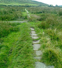
The route starts in Lumbutts, and soon passes the first milestone and follows the London Road to the east, a contouring track that used to be the main road to Halifax before the turnpikes in the valley floor. Stoodley Pike is then visited followed by the Te Deum Stone and the magnificent Withens packhorse causey that returns us to Lumbutts. For the energetic, a 2-mile optional diversion takes us to another superb pre-turnpike milestone alongside another excellent stretch of packhorse causeway before retracing our steps to Lumbutts.
Route Instructions
1. Lumbutts Mill.
2. Lumbutts Milestone.
3. Mankinholes Farm.
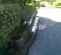
4. Mankinholes Drinking Trough
5. London Road.
6. Swillington-Junction & Stoodley Pike.
7. Dicks Lane Junction.
8. Stoodley Pike
9. Stoodley Pike
10.Te Deum Stone
11. Te Deum Stone Withens
Gate Boundary Stones
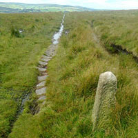
12. Withens Gate Causeway
13. Withens Gate Stoop.
14. Withens Gate Causeway.
15. Hey Head Green Lane-Causeway
16. Hey Head Green Lane Milestone
17. Rake End Causeway
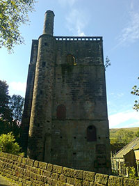
Start from Lumbutts Methodist Chapel and follow the road down the hill. Note the Lumbutts Mill Dams and the Water Mill Tower 1 on your left.
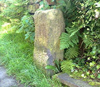
Turn right up the narrow cobbled lane , signposted Pennine Bridleway . At the top of the hill go straight across to another narrow path (Top Brink Inn to your right). Opposite Top Brink Cottage notice the first milestone 2 inscribed HALIFAX 8 miles ROCHDALE 7 miles and BURNLEY 8 miles. Follow this narrow path (complete with causey stones) for ¼ mile to emerge onto a road.
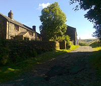
Here you turn right and reach Mankinholes Youth Hostel after 200 yards. Note the 17th Century cottages and farms 3 within the village and also the magnificent drinking trough 4 , a sure sign of the importance of this packhorse route. Have you seen a better example? Just past the trough, turn left, still on the Pennine Bridleway. 5 You are now on London Road, for many centuries the main route along the Calder Valley that steadily contoured along the hillside for many miles visiting Mytholmroyd, Sowerby and Sowerby Bridge before reaching Halifax. Follow London Road for 1.5 miles until you reach a right hand turn sign-posted Pennine Way and Stoodley Pike 6 . This steadily-rising track reaches a wall after 650 yards. 7
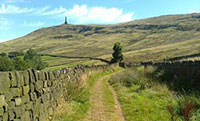
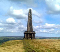
Turn right and head for Stoodley Pike 8, 550 yards away and through another wall-stile. The original Stoodley Pike monument was built in 1815 to celebrate the defeat and abdication of Napolean in 1814. This structure collapsed during a storm in 1854, on the eve of the Crimean War and was replaced by the present structure in 1856 at a cost of £812. Head due south for ¼ mile, still on the Pennine Way and take a path that branches left to shortly reach a ladder stile.
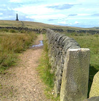
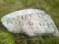
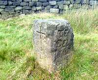
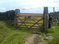
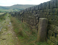
Over the stile, turn right and follow the wall for half a mile on a thin , intermittent and often boggy path to the Te Deum Stone. About half way and 100 yards after a wall is crossed , note a boulder used as a boundary stone. 9 At the Te Deum Stone 10 note the inscription – TE DEUM LAUDAMUS which is Latin for“We Praise Thee O Lord”. The stone was supposedly used to rest coffins on when the dead of Mankinholes and Lumbutts were buried at Cragg Vale before those villages had a burial ground. Turn right through the gate and notice the initials “L” (Langfield) and “S” (Sowerby) carved on the gateposts 11. The locals clearly enjoyed using existing stones to use as boundary stones. The next 300 yards feature 4 stone posts, used to guide travellers across the top of the moor and also a causeway. 12
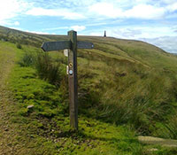
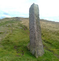
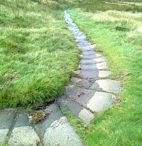
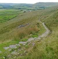
You are now at Withens Stoop 13, a leaning 2-metre high guide stoop in a dramatic position overlooking the upper Calder Valley. Note the nearby wooden waymarkers that confirm this point as a crossroads of the Calderdale Way and the Pennine Way. Go straight ahead on a superb causeway 14 that drops steeply in places back to Lumbutts Methodist Chapel and the start.
This completes the 5-mile walk. If you fancy a couple more miles, from Lumbutts Methodist Chapel turn left down the road and then first left down a track between dams that goes past Lee Farm and around the back of Lumbutts village for a distance of 500 yards. Turn left along a tarmac road. Follow this for ¾ mile to Heyhead Farm . Turn left for a further ¾ mile along a causeway 15, then a rough walled lane and finally another superb causeway until you steadily rise to Rake End. Halfway along the walled lane at note another pre-turnpike milestone 16 with the inscription HALIFAX 9 miles, BURNLEY 7 miles, ROCHDALE 6 miles. From Rake End 17, simply re-trace your steps back to Lumbutts Methodist Chapel.
We hope you have enjoyed this historical stroll, originally devised by Chris Marcus for The Milestone Society and revised by Alan Schofield, Saddleworth Historical Society, www.saddleworth-historical-society.org.uk
The Milestone Society was established in 2001 to campaign for the conservation of milestones and other waymarkers, which are endangered by neglect, by vandalism and by casual destruction. You can find out more about our work plus details of the c 9000 milestones in the UK by visiting our website, www.MilestoneSociety.co.uk
While care has been taken to ensure the information above is accurate, the Milestone Society accepts no liability for any claim, loss, damage or injury (howsoever arising) incurred by those using the information provided. Please ensure that you wear suitable footwear and always carry a drink and a snack.
CLICK HERE to download a PDF to print out this walk
CLICK HERE TO VIEW ROUTE
View Larger Map