HIGHWAYS HERITAGE WALKS
CALDER & HEBBLE NAVIGATION FROM BRIGHOUSE TO SOWERBY BRIDGE WITH MILESTONES , LOCK-KEEPERS COTTAGES AND 250 YEARS OF CANAL HERITAGE
Walk Length: 7 miles. Allow 5 hours
Grade: The route is medium mainly on level tracks, much with tarmac although short sections are on uneven and steep cobblestones, particularly near canal locks. Not suitable for mobility-impaired or young children.
Start: Sowerby Bridge Railway Station.
Grid Reference: GR SE06261 23472
Postcode: HX6 3AB
Public transport: Sowerby Bridge has good bus links with all surrounding towns and train links with Leeds (via Bradford or Dewsbury) and Hebden
Parking: in station car park or on approach road to station.
Description
The first leg is via train to Brighouse. From platform 2 there are hourly trains to Brighouse Monday to Saturday. Once in Brighouse , we walk along Bradford Road before accessing the Calder & Hebble Navigation in the centre of the town. We then follow the canal towpath all the way to Sowerby Bridge visiting over 10 locks on the way as well as 5 canal milestones, numerous quarter and half-mile markers, lock markers and several lock-keepers cottages. The towpath passes Brookfoot, Cromwell Bottom, Elland Bridge, Salterhebble and Copley before arriving in Sowerby Bridge.
Route Instructions
1. Calder & Hebble Brighouse
Ganny Lock Overflow.
2. Calder & Hebble Brighouse Ganny Lock.
3. Calder & Hebble Brookfoot Lock.
4. Calder & Hebble Elland Lock.
5. Calder & Hebble Elland Towpath Bridge.
6. Calder & Hebble Elland Wood Lock.
7. Calder & Hebble Salterhebble
Brooksmouth Aquaduct.
8. Calder & Hebble Salterhebble
Brooksmouth Lock
9. Calder & Hebble Salterhebble Halifax Branch
10.Calder & Hebble Sowerby Bridge Wharf
11. Calder & Hebble Sowerby Bridge
Wharf Agents House
12. Calder & Hebble Sowerby Bridge
Wharf Pulley.
13. Calder & Hebble Woodside Lock.
14. Calder & Hebble Woodside Mills.
15. Fall Ing Series 16-miles Brookfoot
16. Fall Ing Series 17-miles Cromwell Bottom
17. Fall Ing Series 19-miles Salterhebble
18. Fall Ing Series 20-miles Copley
19. Sowerby Bridge RCT
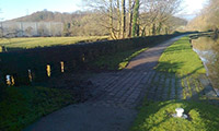
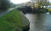
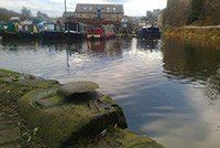
From Brighouse Station we follow Bradford Road, cross Brighouse Bridge and 100 metres later turn left down a short ramp to join the Calder and Hebble Navigation. We then follow the towpath through the centre of the town and reach Ganny Lock (complete with it’s lock-keepers cottage) 1 after half a mile, where the towpath swops from the north to the south bank of the canal. Just after the lock, note the flood overflow feature 2 on the towpath.
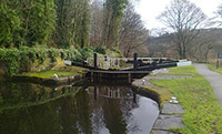
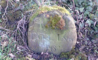
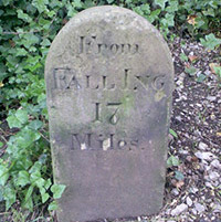
After a further 300 metres the canal reaches Brookfoot and a huge bend where Red Beck flows into the canal and then into the river. Just beyond this is the first canal milestone 3 with the legend “From Fall Ing 16 miles”. After a further 300 metres we cross the canal once more to reach to reach another lock and lock-keepers cottage 4 before a long straight section of canal takes us to the next milestone 5, “From Fall Ing 17 miles”. A further 800 metres takes us to the next 2 locks 6 & 7 which occur in quick succession as we approach Elland.
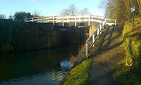
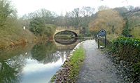
Just before the railway bridge, “From Fall Ing 18 miles” appears almost buried in tarmac. After the railway bridge and then the Elland By-pass road bridge, the towpath originally crossed the canal to the north bank via a towpath bridge 8 the footings of which can still be seen. The route now ascends onto Elland Bridge, turns right and right again before dropping down onto the canal via a narrow cobbled lane. We then pass under Elland Canal Bridge and follow the towpath for 600 metres to Woodside Lock 9.
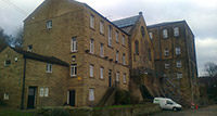
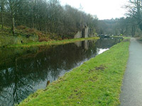
Just beyond, on the north bank, note the remains of Woodside Mills 10, once a major trader of coal, grain and ready-milled flour.
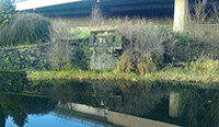
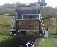
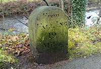
In a further 500 metres, just past the railway bridge, is the next milestone, 11 “From Fall Ing 19 miles”. The next place visited is the Brooksmouth Lock, an unusual “guillotine” lock 12, fitted in 1938 when a road-widening scheme made the original lock unworkable.
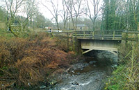
Just beyond is the only aqua duct 13 on the Calder & Hebble, Brooksmouth, where the Hebble Brook (from Halifax) feeds into the River Calder.
We are now at Salterhebble, where a short branch canal 14 went north to Halifax. At Salterhebble Lock and Lock-Keepers House keep left under the railway bridge for the final 2-mile section into Sowerby Bridge. After 700 metres we reach the final “Fall Ing” milestone 15, number 20, although the inscription is largely illegible.
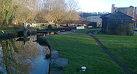
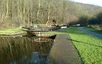
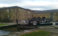
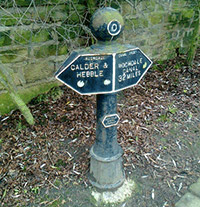
The Calder & Hebble Navigation finishes in Sowerby Bridge at the canal basin where it meets the Rochdale Canal, built in 2106, 25 years after the Calder & Hebble was completed. Note the first Rochdale Canal Trust Marker 16 as well as the metal pulley 17 almost adjacent to it that allowed horses to tow barges around the connecting corner.
The basin 18 & 19 is a fascinating place to spend some time with many original buildings still standing after 250 years. Note the short towpath walk around the site.
The walk finishes by following the towpath onto Sowerby Bridge’s main road. Turn left, follow the road for 400 metres to cross the river, go under the railway bridge and turn left again and follow Station Road for 400 metres to the station.
The Milestone Society was established in 2001 to campaign for the conservation of milestones and other waymarkers, which are endangered by neglect, by vandalism and by casual destruction. You can find out more about our work plus details of the c 9000 milestones in the UK by visiting our website, www.MilestoneSociety.co.uk
While care has been taken to ensure the information above is accurate, the Milestone Society accepts no liability for any claim, loss, damage or injury (howsoever arising) incurred by those using the information provided. Please ensure that you wear suitable footwear and always carry a drink and a snack.
CLICK HERE to download a PDF to print out this walk
View Larger Map